Europe Maps - Professional Mapping & Cartographic Products

|
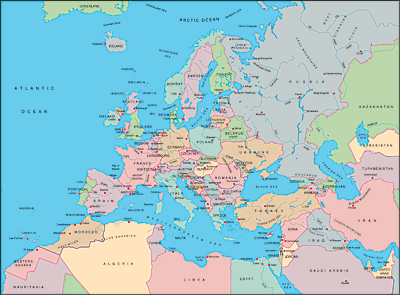
 MOUNTAIN HIGH MAPS® - CONTINENTAL EDITIONS EUROPE - Version 4.0
The unique MOUNTAIN HIGH MAPS® collection of relief maps is available as a separate products for the designer who only requires a smaller selected group of continental maps. The map specifications are identical as for the full Mountain High Maps Edition, including political, vegetation & elevation relief maps and two base grayscalerelief maps JPEG and TIFF Photoshop images along with overlaying vector Illustrator editable EPS map.
MOUNTAIN HIGH MAPS® - CONTINENTAL EDITIONS EUROPE - Version 4.0
The unique MOUNTAIN HIGH MAPS® collection of relief maps is available as a separate products for the designer who only requires a smaller selected group of continental maps. The map specifications are identical as for the full Mountain High Maps Edition, including political, vegetation & elevation relief maps and two base grayscalerelief maps JPEG and TIFF Photoshop images along with overlaying vector Illustrator editable EPS map.
 Europe Mountain High Map #501 Europe Mountain High Map #501
EPS Illustrator geopolitical maps + five styles JPEG relief maps $19
European Union Mountain High Map #502
EPS Illustrator geopolitical maps + five styles JPEG relief maps $19
Europe Continent Mountain High Maps - 23 maps
EPS Illustrator geopolitical maps + five styles JPEG relief maps $29
Product Information |
Technical Specifications
Europe |
EU map |
Mediterranean |
Spain |
France |
Italy |
Germany |
Scandinavia |
British Isles
|
|
MOUNTAIN HIGH MAP FRONTIERS Version 4.0 is a collection of high quality editable outline maps. This superb resource of 78 map views covers the world and consists of coastline, borders, rivers, city locations and longitude/latitude graticules to fit the MOUNTAIN HIGH MAPS® relief map images or can be used independently as a self-contained resource. Each map is available in Adobe Illustrator EPS CS2. Rights allow almost unlimited commercial use.
Product Information
Technical Specifications
Catalog
Europe |
EU map |
Mediterranean
Spain |
France |
Italy |
Germany
Scandinavia |
British Isles
 EUROPE Select from 23 Europe EPS Illustrator geopolitical maps $9 each EUROPE Select from 23 Europe EPS Illustrator geopolitical maps $9 each
|
|
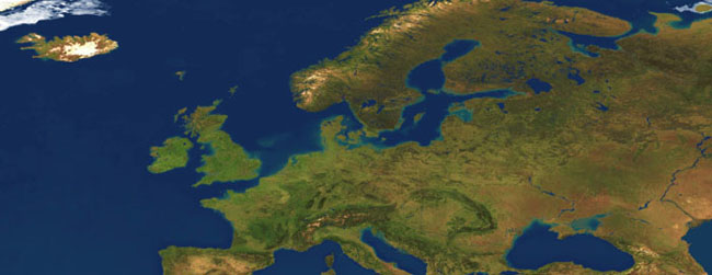
Europe 1 km Satellite Image
Europe Satellite image at 1,000 meter resolution showing land relief sized at 9,600 x 8,400 pixels, giving a printed size of 64 x 56 inches at 150 dpi, or 32 x 28 inches at 300 dpi. The area covered by the satellite image map runs from 20º North to 90º North, and from 30º West to 50º East.
Europe 1 km Satellite Imagery - $9
Europe 250 meter Satellite Image
Europe Satellite image at 250 meter resolution showing land relief sized at 24,825 x 20,774 pixels, giving a printed size of 165 x 138 inches at 150 dpi. The area covered by the satellite image map runs from 25º North to 72º North, and from 25º West to 50º East.
Europe 250 meter Satellite Imagery - $19
|
|
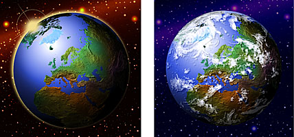
 EARTH IMAGES COLLECTION is a collection of 3D globe views and maps created from Satellite Images, a highly realistic image of the Earth's surface derived from thousands of Earth observation satellite images. Data from 3 satellite systems were combined with digital map and terrain data to produce the natural color Satellite Image. Earth-Images comprises 8 variations of Globe Views - Clouds, Clear sky, Night Sky and Ocean floor texture, all with the optional white background or black background - 1,179 total images including over 100 images of the USA at 5,000 meters per pixel resolution. Each image is at 22.5º increment North or South, East and West to give complete coverage from any perspective. Also included a selection of world views focused on 3 different areas in 3 styles, and a collection of Continental Views taken from 6 locations in 3 styles each. For details see www.earth-images.com EARTH IMAGES COLLECTION is a collection of 3D globe views and maps created from Satellite Images, a highly realistic image of the Earth's surface derived from thousands of Earth observation satellite images. Data from 3 satellite systems were combined with digital map and terrain data to produce the natural color Satellite Image. Earth-Images comprises 8 variations of Globe Views - Clouds, Clear sky, Night Sky and Ocean floor texture, all with the optional white background or black background - 1,179 total images including over 100 images of the USA at 5,000 meters per pixel resolution. Each image is at 22.5º increment North or South, East and West to give complete coverage from any perspective. Also included a selection of world views focused on 3 different areas in 3 styles, and a collection of Continental Views taken from 6 locations in 3 styles each. For details see www.earth-images.com
Earth Images Collection
1,000+ Globe Views
JPEG Satellite Images of the World from every angle $19
Product Information |
Technical Specifications
VIEW EARTH IMAGES CATALOGS:
Clear view 1 |
Clear view 2 |
Cloud cover 1 |
Cloud cover 2
Ocean floor 1 |
Ocean floor 2 |
Night lights 1 |
Night lights 2
|
|

EUROPE POWERPOINT MAPS Digital Wisdoms collection of Mountain High Maps for PowerPoint® Presentations is delivered as a Microsoft PowerPoint® PPT format file and can be easily and speedily edited within PowerPoint® application to create a map with a wide number of impressive variations to meet your presentation needs. Options are available for individual PPT maps, elevation relief, vegetation relief and political color fill versions, or a bundle of all three versions. Go to Map Catalog to view download options.
POWERPOINT MAPS 250 map collection $9
Product Information |
Catalog
|
|
 GLOBESHOTS® is a distinctive collection of high quality relief globe images with enhanced 3D effect. This superb resource of 100 high resolution (300 dpi) TIFF RGB and 164 low resolution (72 dpi) PICT/BMP colorized globes show the world in 5 general categories and 39 specific viewpoints - equatorial, polar, strategic, oceanic and continental. The Relief Globes are presented in a range of styles and colors, with and without cloud cover, with masks and artwork to reconfigure the globes with interchangeable foregrounds and backgrounds, including blends, halo and star effects. Masks are provided to remove the globes from their background and provide shading effects. To view the complete catalog of globes and review product information and licensing details see www.globe-world.com GLOBESHOTS® is a distinctive collection of high quality relief globe images with enhanced 3D effect. This superb resource of 100 high resolution (300 dpi) TIFF RGB and 164 low resolution (72 dpi) PICT/BMP colorized globes show the world in 5 general categories and 39 specific viewpoints - equatorial, polar, strategic, oceanic and continental. The Relief Globes are presented in a range of styles and colors, with and without cloud cover, with masks and artwork to reconfigure the globes with interchangeable foregrounds and backgrounds, including blends, halo and star effects. Masks are provided to remove the globes from their background and provide shading effects. To view the complete catalog of globes and review product information and licensing details see www.globe-world.com
GlobeShots Collection - Globe Views $19
Product Information |
Technical Specifications
|
Digital Wisdom Inc.
USA & Canada orders: 800-800-8560 - International orders: 804-443-9000
Any comments or problems with this
site? Please
let us know
- thank you!
Digital Wisdom Inc., Box 11, Tappahannock VA 22560-0011, USA
© Digital Wisdom, Inc.
|